Fișier:Ganymede terrain.jpg
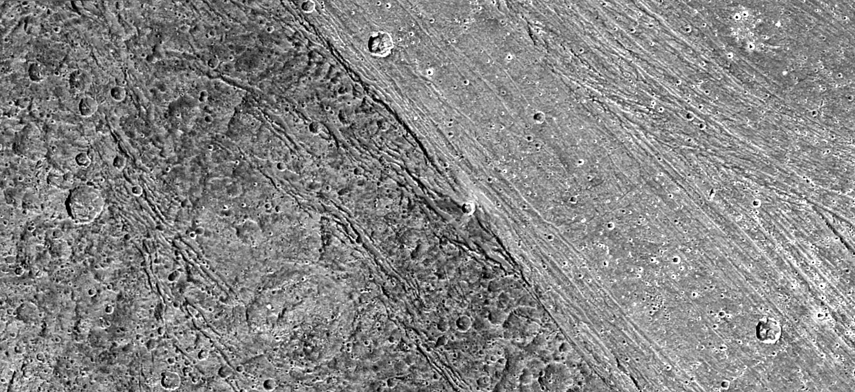
Terrain on Ganymede.
| Acest fişier este în domeniul public fiindcă a fost creat de NASA. Politica drepturilor de autor a NASA spune că „Materialul NASA nu este protejat de dreptul de autor atâta timp cât nu se precizează altfel”. (NASA copyright policy page sau JPL Image Use Policy). | ||
 |
Atenţie:
|
| Descriere |
English: Boundary between dark and light terrain on Ganymede. The photo is PIA02577 at the JPL Planetary Photojournal. It was taken by the Galileo spacecraft.
Original NASA caption: The ancient, dark terrain of Nicholson Regio (left) shows many large impact craters, and zones of fractures oriented generally parallel to the boundary between the dark and bright regions of Jupiter's moon Ganymede. In contrast, the bright terrain of Harpagia Sulcus (right) is less cratered and relatively smooth. The nature of the boundary between ancient, dark terrain and younger, bright terrain, the two principal terrain types on Ganymede, was explored by NASA's Galileo spacecraft on May 20, 2000. Subtle parallel ridges and grooves show that Harpagia Sulcus's land has been smoothed out over the years by tectonic processes. North is to the top of the picture. The Sun illuminates the surface from the left. The image, centered at ?14 degrees latitude and 319 degrees longitude, covers an area approximately 213 by 97 kilometers (132 by 60 miles.) The resolution is 121 meters (about 250 feet) per picture element. The images were taken on May 20, 2000, at a range of 11,800 kilometers (about 7,300 miles). |
| Sursă | http://photojournal.jpl.nasa.gov/catalog/PIA02577 |
| Autor | NASA/JPL/DLR |
Istoricul fișierului
Apăsați pe Data și ora pentru a vedea versiunea fișierului trimisă la momentul respectiv.
| Data și ora | Miniatură | Dimensiuni | Utilizator | Comentariu | |
|---|---|---|---|---|---|
| actuală | 4 iunie 2005 21:58 | | 1.764x809 (729 KB) | wikimediacommons>Dbenbenn | 1764x809 version, converted from TIF with quality 95% |
Utilizarea fișierului
Următoarea pagină folosește acest fișier: